WEST PALM BEACH, FL. (THECOUNT) — A new 
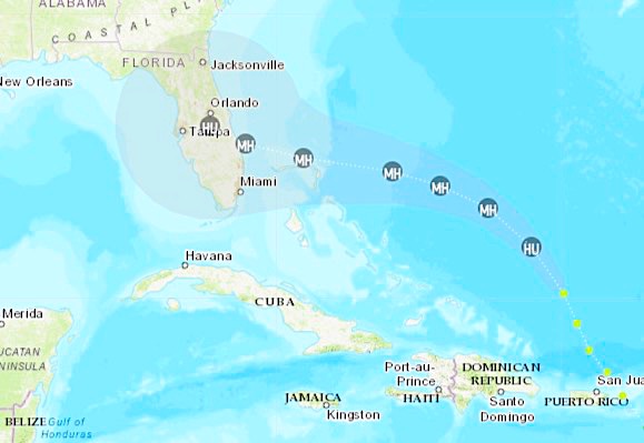
Hurricane Dorian track map shows West Palm Beach and Fort Lauderdale squarely in its crosshairs.

The National Hurricane Center said the Category 1 storm is expected to strengthen into a potentially catastrophic Category 4 with winds of 130 mph (209 kph) and slam into the U.S. on Monday somewhere between the Florida Keys and southern Georgia — a 500-mile stretch that reflected the high degree of uncertainty this far out, reports AP on Thursday evening.

Advertisement

“If it makes landfall as a Category 3 or 4 hurricane, that’s a big deal,” said University of Miami hurricane researcher Brian McNoldy. “A lot of people are going to be affected. A lot of insurance claims.”

As of Thursday evening, Dorian was centered about 330 miles (535 kilometers) east of the Bahamas, its winds blowing at 85 mph (140 kph) as it moved northwest at 13 mph (20 kph).

It is expected to pick up steam as it pushes out into warm waters with favorable winds, the University of Miami’s McNoldy said, adding: “Starting tomorrow, it really has no obstacles left in its way.”

DEVELOPING::

Geo quick facts: West Palm Beach is a city in South Florida. It’s separated from neighboring Palm Beach by the Lake Worth Lagoon. Downtown’s Clematis Street and CityPlace districts are filled with restaurants, shops, bars and clubs. The Norton Museum of Art displays American, European and Chinese art, including Impressionist paintings. Nearby, the 4-theater Kravis Center for the Performing Arts hosts concerts, plays, dance and opera – wikipedia.