

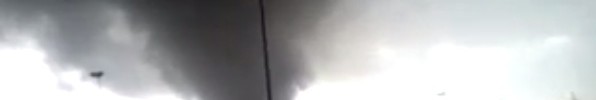
Storm chasers reporting large hail spotted. ROTATION SPOTTED. HEAR LIVE SCANNER FEED BELOW. BASEBALL SIZE HAIL REPORTED. Hooverville golfball size hail. Denton hail storm. HWY 380 tornado spotted. Trees down Clover and Sherwood Denton. LIVESTREAM BELOW.
Tornado Watch 52 is in effect until 9:00 pm CDT For the following locations TX.
|
Advertisement |
LIVE STORM CHASER SCANNER TRAFFIC
DENTON COUNTY POLICE RESCUE LIVE SCANNER
Texas counties included are Anderson Bell Bosque Bowie camp Cass Cherokee Collin Comanche Cooke Coryell Dallas Delta Denton Ellis Erath Falls Fannin Franklin freestone Grayson Gregg Hamilton Harrison Henderson Hill Hood Hopkins Hunt Johnson Kaufman Lamar Lampasas Leon limestone Marion Mclennan Milam Mills Morris Navarro Palo Pinto Parker rains Red River Robertson Rockwall Rusk Smith Somervell Tarrant Titus Upshur Van Zandt wise Wood.
Excerpted from ready.gov
Before:
- Build an emergency kit and make a family communications plan.
- Be alert to changing weather conditions. Look for approaching storms.
- Look for the following danger signs:
- Dark, often greenish sky
- Large hail
- A large, dark, low-lying cloud (particularly if rotating)
- Loud roar, similar to a freight train.
- If you see approaching storms or any of the danger signs, be prepared to take shelter immediately…
- More about:
- What to do before a tornado.
During:
- If you are under a tornado warning, seek shelter immediately! Most injuries associated with high winds are from flying debris, so remember to protect your head.
- If you are in a structure, go to a pre-designated shelter area such as a safe room, basement, storm cellar, or the lowest building level. If there is no basement, go to the center of an interior room on the lowest level (closet, interior hallway) away from corners, windows, doors, and outside walls.
- If you are in a trailer or mobile home, get out immediately and go to the lowest floor of a sturdy, nearby building or a storm shelter.
- If you are outside with no shelter, immediately get into a vehicle, buckle your seat belt and try to drive to the closest sturdy shelter. Do not get under an overpass or bridge. You are safer in a low, flat location. Watch out for flying debris. Flying debris from tornadoes causes most fatalities and injuries.
- More about:
- What to do during a tornado.
What is a Tornado Watch?
WatchWarning
This is issued by the National Weather Service when conditions are favorable for the development of tornadoes in and close to the watch area. Their size can vary depending on the weather situation. They are usually issued for a duration of 4 to 8 hours. They normally are issued well in advance of the actual occurrence of severe weather. During the watch, people should review tornado safety rules and be prepared to move a place of safety if threatening weather approaches. A Tornado Watch is issued by the Storm Prediction Center (SPC) in Norman, Oklahoma. Prior to the issuance of a Tornado Watch, SPC will usually contact the affected local National Weather Forecast Office (NWFO) and they will discuss what their current thinking is on the weather situation. Afterwards, SPC will issue a preliminary Tornado Watch and then the affected NWFO will then adjust the watch (adding or eliminating counties/parishes) and then issue it to the public. After adjusting the watch, the NWFO will let the public know which counties are included by way of a Watch Redefining Statement. During the watch, the NWFO will keep the public informed on what is happening in the watch area and also let the public know when the watch has expired or been cancelled. Source: weather.gov